


la ciotat l'arche et baou rous

ego
User
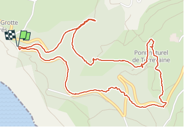

Length
3.9 km

Max alt
370 m

Uphill gradient
161 m
Km-Effort
6 km

Min alt
226 m

Downhill gradient
158 m
Boucle
Yes
Creation date :
2024-02-29 10:00:43.498
Updated on :
2024-02-29 14:08:49.078
1h50
Difficulty : Medium

FREE GPS app for hiking
 SityTrail
IGN / Geographical institutes
SityTrail Plus
The world is yours!
About
Trail Walking of 3.9 km to be discovered at Provence-Alpes-Côte d'Azur, Bouches-du-Rhône, La Ciotat. This trail is proposed by ego .
Positioning
Country:
France
Region :
Provence-Alpes-Côte d'Azur
Department/Province :
Bouches-du-Rhône
Municipality :
La Ciotat
Location:
Unknown
Start:(Dec)
Start:(UTM)
708342 ; 4784478 (31T) N.
Comments